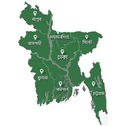
Interactive Divisional Maps Bangladesh
·
Interactive Bangladesh divisional map with clickable regions, shortcode support, and configurable colors.
평가
버전
2.0.0
활성화된 설치 항목
100
최근 업데이트일
Jul 18, 2026

Display an interactive map of Bangladesh with 8 clickable divisional regions.
The plugin lets you: – Add the map using a widget or shortcode. – Set custom links for each division. – Configure division fill color, hover color, and river line color from the settings page. – Reuse one global configuration across all widget instances.
This is useful for news portals, local directories, educational websites, and any site that needs region-based navigation for Bangladesh.
Usage
- Widget: ‘Interactive Divisional Maps’
- Shortcode: [interactive_divisional_maps_bd]
Credits
- Developer: ALI IMRAN
- E-Mail: imran4dev@gmail.com
- Website: imran.link
License
This program is free software; you can redistribute it and/or modify
it under the terms of the GNU General Public License as published by
the Free Software Foundation; either version 2 of the License, or
(at your option) any later version.

This program is distributed in the hope that it will be useful,
but WITHOUT ANY WARRANTY; without even the implied warranty of
MERCHANTABILITY or FITNESS FOR A PARTICULAR PURPOSE.  See the
GNU General Public License for more details.

You should have received a copy of the GNU General Public License
along with this program; if not, write to the Free Software
Foundation, Inc., 51 Franklin St, Fifth Floor, Boston, MA  02110-1301  USA